Personal reflection
For this blog, I would like to reflect on my own experience of learning GIS throughout this term.

For this blog, I would like to reflect on my own experience of learning GIS throughout this term.

For this lab assignment, I was assigned to produce 2 maps of the Municipality of Squamish for analyzing the potential impact of environmental impact at the elevation of 600m after building a new ski place.
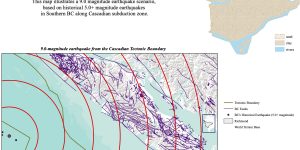
For our final project, my group members are curious about the potential risk in Richmond, BC since we all know that Vancouver will have an earthquake happen in the future. Therefore, we created four maps in order to demonstrate the risk of Richmond.
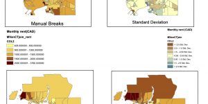
For this assignment, I used the 2016 Census data from Statistics Canada in order to analysis rental housing cost and affordability in Metro Vancouver. By showing the differences, I created 4 maps by using different classifications (Natural Breaks, Equal Interval Classification, Manual Breaks and Standard Deviation).
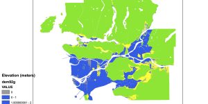
For this lab assignment, it provides a storm surge scenario in Metro Vancouver for me to analysis which areas of Metro Vancouver are dangerous. In order to find out which areas are dangerous, I have produced 4 maps of a storm surge of Metro Vancouver.